September – October
Journey to the northeastern corner of the state, where Hells Canyon reveals some of Oregon’s earliest terrain and is marked by remnants of a dark history.
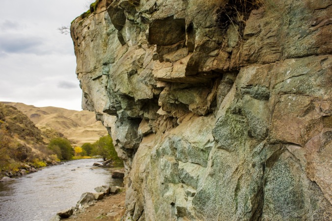
Hells Canyon is one of Oregon’s natural wonders, and its breathtakingly dramatic beauty is obvious to any observer. But our continent’s deepest canyon holds a secret that makes it even more tantalizing to explore – Hells Canyon is actually a time machine.
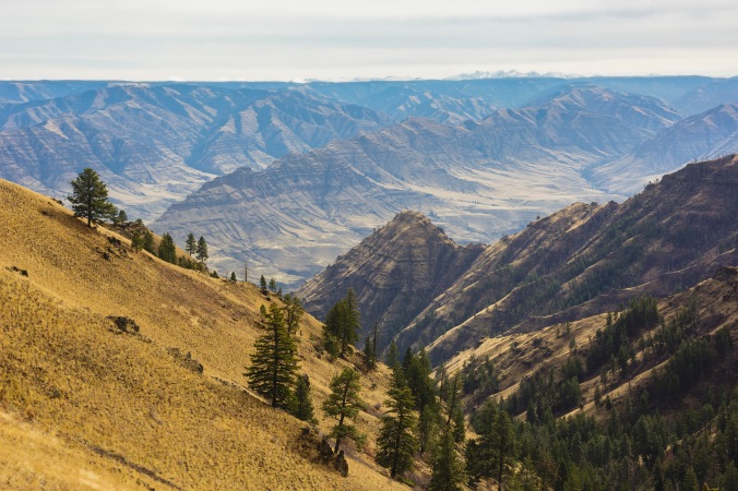
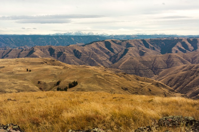
(Part of Hells Canyon: Cow Creek and the Imnaha River Canyon in the middle ground, as seen from Spain Saddle. The Seven Devils Peaks in Idaho on the horizon)
The waters of the Imnaha River, which created a large part of the canyon, have relentlessly carved away at the Columbia River basalt that covers the old volcanic islands of the Blue Mountains. These islands became cemented to North America on the edge of what is now called Idaho 160 to 120 million years ago, becoming some of Oregon’s first land.
Armed with a book or two, a sturdy vehicle, and some good hiking boots, you can rediscover this ancient part of Oregon. As you explore the floor of a vanished ocean, the foundations of former islands, and massive floods of lava that originated underneath Yellowstone, you’ll come across the ghostly remains of a mining town that went boom and bust under suspicious and disastrous circumstances; trace the steps of the Nimíipuu (True People) and their admired leader, Young Chief Joseph, as they fled from the US Army; and witness the spot where over thirty Chinese miners were murdered by cowboys for their gold.
Luckily for today’s travelers, the town of Joseph (named after the Nimíipuu leader’s father in 1880, while his son was living in exile from his homeland) now offers a charming spot to serve as a base for explorations of the canyon. Accommodations around town range from tents, yurts, and RV sites to large cabin rentals, with nice motels, B&Bs (and Airbnbs) and an historic 1920s lodge occupying the middle of the spectrum. Almost everywhere in the vicinity of Joseph has beautiful views of the Wallowa Mountains, and there are many options for camping and lodging around large Wallowa Lake.
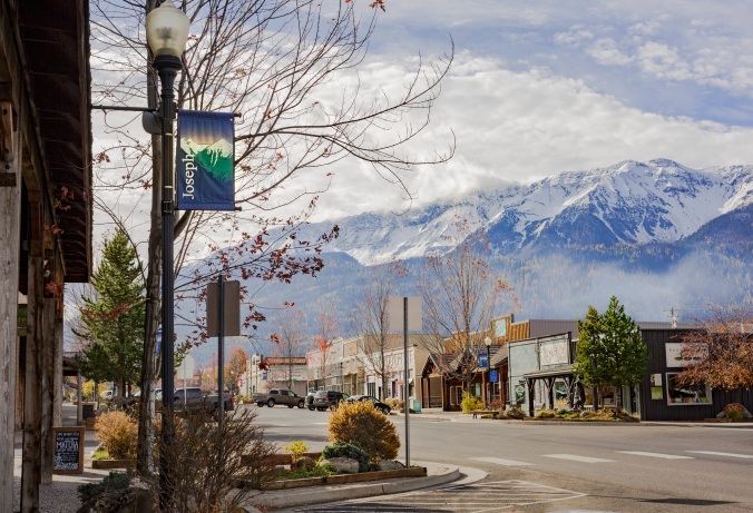
(Main Street, Joseph, OR)
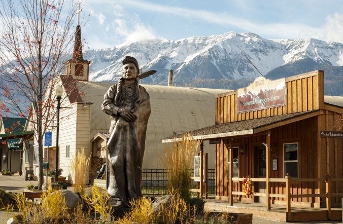
(Statue of Chief Joseph the Younger, or Hinmuuttu-yalatlat, “Thunder Rolling Down the Mountain”)
Be prepared for extreme changes in climate as you descend down into the canyon, which seems to be aptly named, as it will get hotter the farther down that you go. Because of the heat at the bottom, this journey is not recommended in the summer months. In September, the weather becomes more ideal; by October, rates for lodging may decrease; but by November, expect chilly temperatures and possibly snow above the canyon. Spring is generally wet, so early fall is the best time to plan your visit.
I recommend two guidebooks to lead you on your adventure through the history of Hells Canyon: Hiking Oregon’s Geology by Ellen Morris Bishop and William L. Sullivan’s 100 Hikes/Travel Guide of Eastern Oregon. The former has a great introduction that gives you an overview of the state’s geology, and Morris Bishop has listed three hikes through the canyon that outline what to look for and how to interpret the geological features that you will see. Sullivan’s book covers the same territory with helpful maps, detailed directions and information about the flora, fauna, and human history of the area.
To get a stunning overview of the canyon before you venture into its depths, Buckhorn Overlook/Lookout is the place to begin. A fire lookout from the 1930s perches on the edge of the canyon over the Imnaha’s valley, and on the horizon the high Seven Devils peaks of Idaho pierce the sky. Another book I recommend to bring history to life here is the classic Indian Legends of the Pacific Northwest by Ella Elizabeth Clark, an early ethnographer. In the pages of her book she has printed an origin myth about the Seven Devils Mountains, corroborated by a Nimíipuu, (or Nez Perce) man named Caleb Whitman in 1950. The story features Coyote as hero/creator and illuminates the mountains’ striking name. It will add a dimension to the land and its wildlife by allowing you to view it through the lens of the historical indigenous culture — and the story itself is great fun to read aloud to any fellow travelers.
If you would like a moderate hike,* you can follow Sullivan’s suggestion to Eureka Viewpoint and get an even better view of the canyon. If you’re up for a more strenuous adventure the following day, and you’re willing to backpack and camp in the canyon overnight, you can follow Morris Bishop’s hike to Coon Hollow near the Cache Creek Ranch (a shepherding outfit until the 1930s, now an occupied Forest Service building) on the Snake River. Here you’ll get a close up view of the sedimentary rocks left by the sea that once separated “Oregon” from “Idaho” and perhaps find some fossils of gingkos, palms, conifers, and ferns left in those ocean sands.

(Eureka Viewpoint)
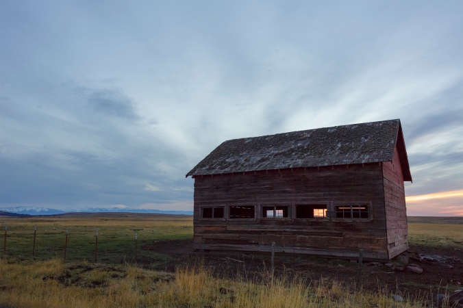
(A barn by the road through Zumwalt Prairie)
On your return from the Buckhorn Overlook area or Coon Hollow hike, or on another day, you might want to take a jaunt through the Zumwalt Prairie Preserve. Here the Nature Conservancy has protected the grassland with the largest private preserve in Oregon. The natural environment supports a wide range of wildlife, and birds of prey especially thrive in it. You will most likely see hawks soaring across the road and deer and elk grazing nearby as you drive through the area, but the chance to walk through the prairie itself should not be missed, if time and energy permit — and the view from Harsin Butte is spectacular.
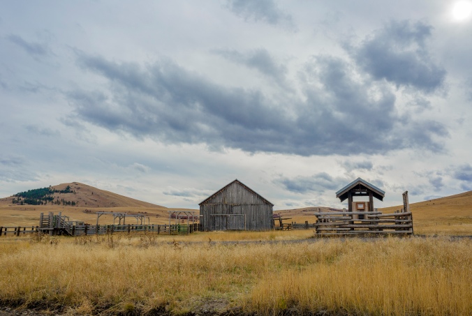
(Information at the old barn and corral on the Zumwalt Prairie Preserve with Harsin Butte in background)
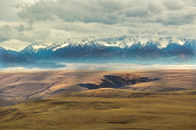
(The Wallowas from Harsin Butte)
(The Seven Devils and Hells Canyon from Harsin Butte)
For another day’s journey, you can lift stakes and drive to the town of Imnaha from Joseph (with a full tank of gas), then head north, driving along the Imnaha River itself. There’s a lonely and pleasant-looking B&B, for a more comfortable alternative to camping, just before the road crosses the river to the west. Once the Lower Imnaha Road becomes NF-4260, be prepared for a long and bumpy ride to the Imnaha River Trailhead. When you reach it, you can then hike through the valley that you viewed from Buckhorn Overlook on a previous day.
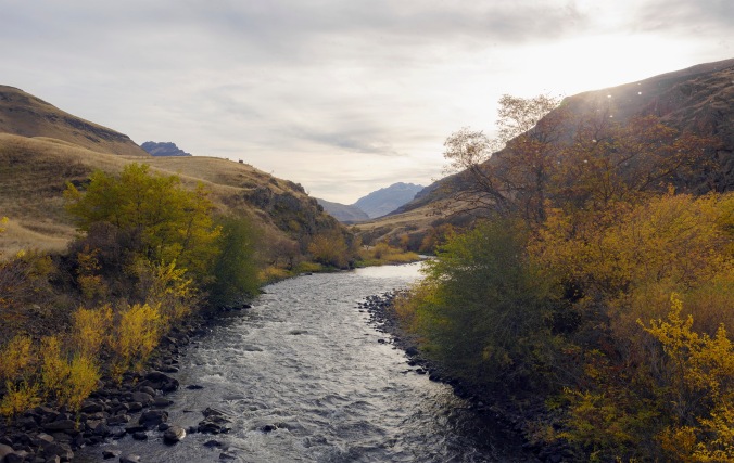
(The Imnaha River)
This trail travels along the river through an old magma chamber of the Blue Mountain island arc, where greenish white diorite that was formed 260 million years ago, before the land became a part of North America, is on display. About 4 miles down, a campsite awaits backpackers at Eureka Bar, where the Imnaha meets the Snake River. Nearby is an old mining tunnel, where miners once claimed to have found copper and then gold in the ancient rock, but now Townsends big-eared bats have taken up residence there. A short walk away, the ruins of a gold stamp mill and other buildings are all that remain of the town called Eureka that sprang up at the turn of the 20th century. The apparently unsubstantiated claims of gold gave birth to a rush of investment from financiers back East – only to go belly up when the Imnaha paddlewheel steamer that carried machinery for the mill crashed and sank on the Snake River, and the questionable and disastrous gold rush met its end.
(Diorite, some of the oldest land in Oregon, along the Imnaha River Trail)

(Holding a bit of Oregon’s geological origins in my hand)
One last hike in the nearby vicinity will take you through the more recent geological strata of Oregon and bring you close to the experience of one of the most venerated figures of the state, as well as a less remembered, but significant, part of Oregon’s history.
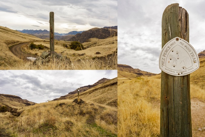
On the other side of the Imnaha River is the Nez Perce or Nee-Mee-Poo National Historic Trail, which actually stretches from the town of Minam, (northwest of Joseph, marking the western boundary of the Nimíipuu’s ancestral land) to the Bear Paw Battlefield in northern Montana, where Hinmuuttu-yalatlat (Thunder Rolling Down the Mountain, or Chief Joseph the Younger) was forced to surrender with 700 of his remaining people. They were captured just 40 miles from the safety of Canada, where they were fleeing in hopes of joining Sitting Bull and the Lakota. To see a map of the Nimíipuu’s arduous and deadly flight go here.
Hiking (or even rough driving) the four or so miles from the Cow Creek bridge to Dug Bar, where the Nimíipuu crossed the Snake River, will only give you a fractional taste of the 1,170 miles that the Wallowa band endured in a bid for freedom before their surrender in 1877. Read up on the history before you go, even if it’s just a cursory look at Wikipedia; or pick up one of the many books that have been written on the subject (for all ages) and bring it with you. (A more recent publication for adults is The Last Indian War: The Nez Perce Story, by Elliott West.)
(Only a tiny part of the land that the Nimíipuu trekked across in their flight)
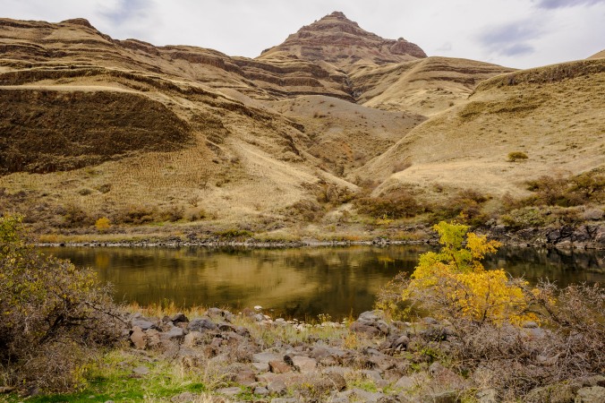
Successive layers of Columbia River basalts will be visible from Cow Creek to Dug Bar. The Columbia River, northern boundary of most of Oregon, does, indeed, run through these lava flows, but they originated from great rifts in the land of northeastern and southeastern Oregon, caused by the Yellowstone hotspot. The Snake River, which forms most of Oregon’s eastern boundary before it flows into the Columbia, also has its headwaters in Yellowstone Park.
(The Nimíipuu crossing of the Snake River at Dug Bar, below Columbia River basalt flows)
If you’re up for more tramping and willing to get your feet wet, you can continue from Dug Bar along the Snake River Trail into the Hells Canyon Wilderness, splash across Dug Creek a few times, and camp or even swim along this part of the Snake River. A little bit farther upstream, where Deep Creek meets the Snake, Chinese Massacre Cove testifies to the crime that gave its name to this rocky beach. In 1886, thirty-two Chinese men were shot dead here by seven cowboys from Idaho, and their bodies were dumped into the river. The gold mined by the Chinese men was then buried at the cove by the murderers, and one Chinese vial of gold dust was discovered here in 1902.
There may be more bloody buried treasure to be found, but in my opinion, it would best be left in the ground. The human history in this wonderful natural area is scarred by the violence and destruction that greed for gold brought – from the sinking of the Imnaha to the murdered miners. The gold rush was even responsible for the plight of the Nimíipuu, as gold-mad settlers pushed the US government to demand more territory from the peaceful native people. The real worth in the stones of Hells Canyon is in the stories they have to tell – reminding us of our insignificantly brief existence in comparison to the Earth’s, and of the good, bad, and ugly qualities of human nature.
*When planning hikes, make sure to check driving and hiking times and sundown time. [See the Google map I created for this trip: one-way standard drive times are noted in the directions on the sidebar. Click on the hiking icons to see estimated hiking times (not including breaks).] Always bring water, food, first aid supplies, and a trail map, and prepare for weather conditions when hiking. In this part of Oregon, rattlesnakes are common — I recommend packing a snake bite kit. The drive into the canyon, especially to Dug Bar, is best done in a high clearance vehicle with 4-wheel-drive, and camping overnight is advisable to avoid driving the road after dark.
Text copyrighted by Emily Wahl. Photos copyrighted by Eric Macey.
