*Shortly before this article was published, a week after our visit, the Chetco Bar wildfire was reported, having been sparked by lightning. It eventually spread all the way to the edge of Brookings. Though we have not been back to the area yet, the Statesman Journal reported that Vulcan Lake, Loeb State Park, and the Redwood Nature Loop were untouched.
July – August
Explore a wide variety of landscapes, from seaside to mountaintop, created by former islands along the southwest coast of Oregon and northern California.
There may be some rivalry between Oregonians and Californians, but, as neighbors, the two states share land that is all of one piece geologically and ecologically, though divided by an imaginary line. The Klamath Mountain region in southwestern Oregon offers a climate and forestland usually associated with northern California, with its balmy ocean air and towering redwood trees.
Like the Blue Mountains, the foundations of the Klamath range were once volcanic islands, before they were swept onto the edge of North America between 160 and 120 million years ago. The highest peaks of the range are in California, but Oregon’s share of the Klamaths includes some dramatic and interesting geological features — from a red mountain ridge formed by the Earth’s mantle as it was thrust above ground by the collision of the islands and the continent, to a cave system made of marble that was formed by the awesome pressure of the colliding land, crystallizing the limestone of Triassic coral reefs. Later, in the Jurassic period, the butting of the land masses forced molten rock up through the shale of the ocean bed to form the granitic pluton of Mt. Ashland.
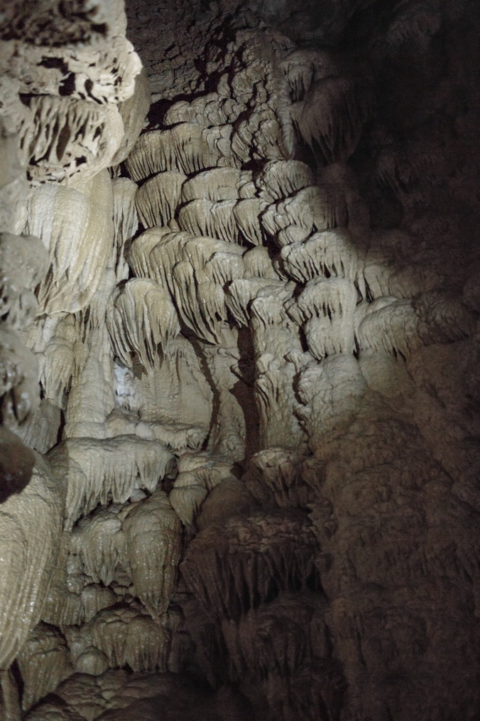
(A portion of the Oregon Caves known as “Paradise Lost”; the formations are made of calcite, which originates from the shells or skeletons of sea life that slowly accreted into the limestone of the ocean floor around the Klamath island chain.)
Though winters are mild at lower elevations, routes will be blocked by snow at the heights of this journey until the summer months. I recommend making this trip during July or August, in order to catch the wildflower shows on Mt. Ashland at their best and to hopefully avoid rain on the coast.
To explore this second oldest part of Oregon, begin by making your base of operations in Brookings, a coastal fishing town. There are lots of motels, a few B&Bs, and many vacation rentals available in the area, mostly in the middle price range. You can easily stroll down to the ocean after dinner in town, but a ten-minute drive north on the Pacific Coast Highway will take you to the more remote Samuel H. Boardman State Park for a nice seaside hike.* I recommend taking William L. Sullivan’s Oregon Coast & Coast Range 100 Hikes/Travel Guide to help you navigate your adventures in this area. He outlines many options for stops and jaunts along the shore, but I suggest rambling around on Cape Ferrelo in the evening and down to the little “pocket” beach just north of it to catch the sunset over the ocean waves.
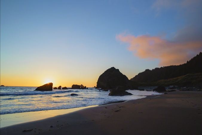
(The beach on the north side of Cape Ferrelo)
For an easy morning hike, drive up the north bank of the Chetco River from Brookings to the Redwood Nature Trailhead in an outlying patch of the Rogue River-Siskiyou National Forest. This trail will take you for an easy loop through the northern-most grove of Sequoia sempervirens, or coast redwood. Earth’s tallest trees, the redwoods have evolved since the Jurassic period, and they once covered most of the coast of California and this corner of Oregon, before commercial logging began in the 19th century. According to the Save The Redwoods League, only 5% of the coast redwoods have not been logged, and only 23% are now protected. The National Forest Service claims that some of the redwoods here in Oregon may be up to 800 years old. To learn more about the redwoods before you visit them in person, pick up a copy of Coast Redwood: A Natural and Cultural History.
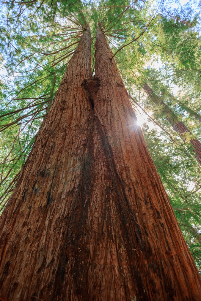
(A coast redwood, or Sequoia sempervirens, that has cloned itself)
Just south of the Redwood Nature Trail, you can see another tree that is unique to California and the Klamath region of Oregon – the Oregon myrtle or California bay laurel (depending on where you are or who you ask.) Alfred A. Loeb State Park began as land preserved by a group called Save the Myrtlewoods in 1948, and its Riverview Trail starts across the road from the Redwood Nature Trail and leads down to a beach on the Chetco River. The myrtle’s fragrant leaves are similar to the Mediterranean bay laurel and were used as medicine by the area’s indigenous people. Its wood is also prized, and was used as legal tender during the Great Depression in North Bend, Oregon, just up the coast. Clearly, its value necessitates the tree’s protection, like so many of the others that make up the great forests of the Pacific Northwest.
For a full day’s outing, have yourself a picnic lunch, then continue to drive up North Bank Chetco River Road, which becomes NF-1376 as you enter the National Forest proper. Turn right and head east on Red Mountain Road, or NF-1909, following signs for the Kalmiopsis Wilderness and Vulcan Lake. Keep on this gravel road for many twists and turns, and be prepared for very rough spots and deep washed-out ruts. After it becomes NF-260, a short right fork, marked by a well scratched post on the left and an old whitewashed outhouse on the right, will bring you to the Vulcan Peak and Chetco Lake Trailheads, before the road becomes even more narrow and treacherous as it winds around the mountain ridge itself to Vulcan Lake. The drive is best done in a high clearance four-wheel-drive vehicle, and I don’t recommend trying to drive to Vulcan Lake until the road is improved.
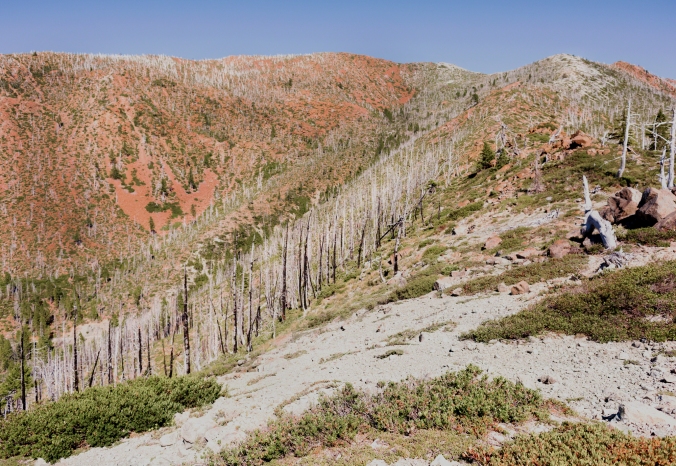
(The trail to Vulcan Peak over a mountain ridge of peridotite, formed from the Earth’s mantle)
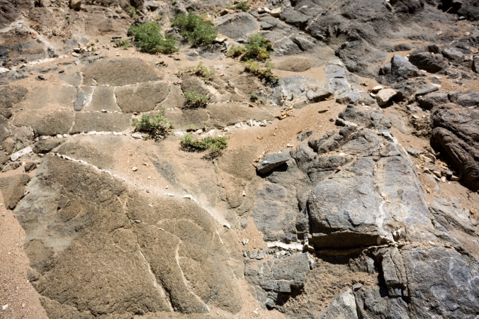
Sullivan includes the hike up to the peak along with the one to Vulcan Lake, of which you will get a view when you climb the 1.3 miles and 900 feet in elevation to the top of the rocky ridge. You will also be able to see the ocean, the Kalmiopsis wilderness to the north and the Siskiyou Mountains in California from this vantage point, but what really makes this area significant are the striking red rocks of the landscape, exposed when a fire destroyed the forest that once covered these steep slopes. In Hiking Oregon’s Geology, Ellen Morris Bishop explains that these rocks, called peridotite, were formed from the Earth’s crumpled mantle when North America ran into the Klamath microcontinent. When broken, they reveal a dark green color, but their oxidized outer rust-red surface must have reminded the person who named Vulcan Peak of the Roman god’s fiery hot forge.
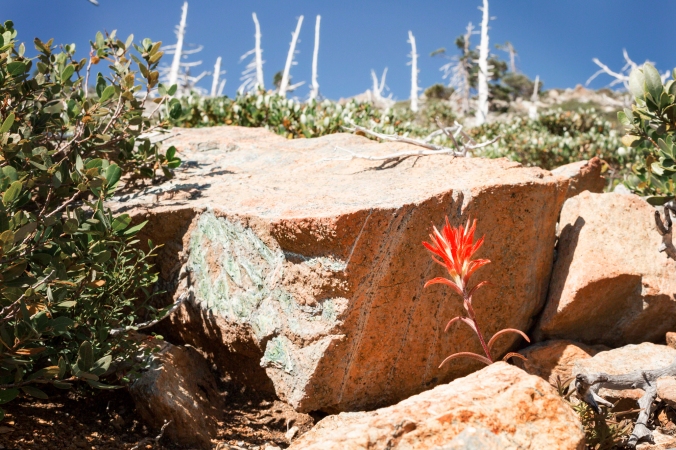
(Peridotite — actually green, but high in iron, so it oxidizes to rust red where exposed to air– and the wildflower, Castilleja, or paintbrush)
The next day, pack your bags and dip down into California on your drive to the Oregon Caves National Monument, just east of Cave Junction. Try to arrive early, because this is a popular destination in the summer. There’s no need for a guidebook here — admittance to the cave is only by a 90-minute guided tour, the last one of the day ending at 6pm. (You can make a reservation online here.) An additional, more rugged tour that you must reserve in advance is also available, as well as a Candlelight Tour. The marble that the seeping rainwater has carved and sculpted in the caves began its existence as the shells and bones of living sea creatures about 220 million years ago, provided refuge for a bear from Elijah Davidson’s dog in 1874, leading to its “discovery” — and it still shelters bats and other animals.
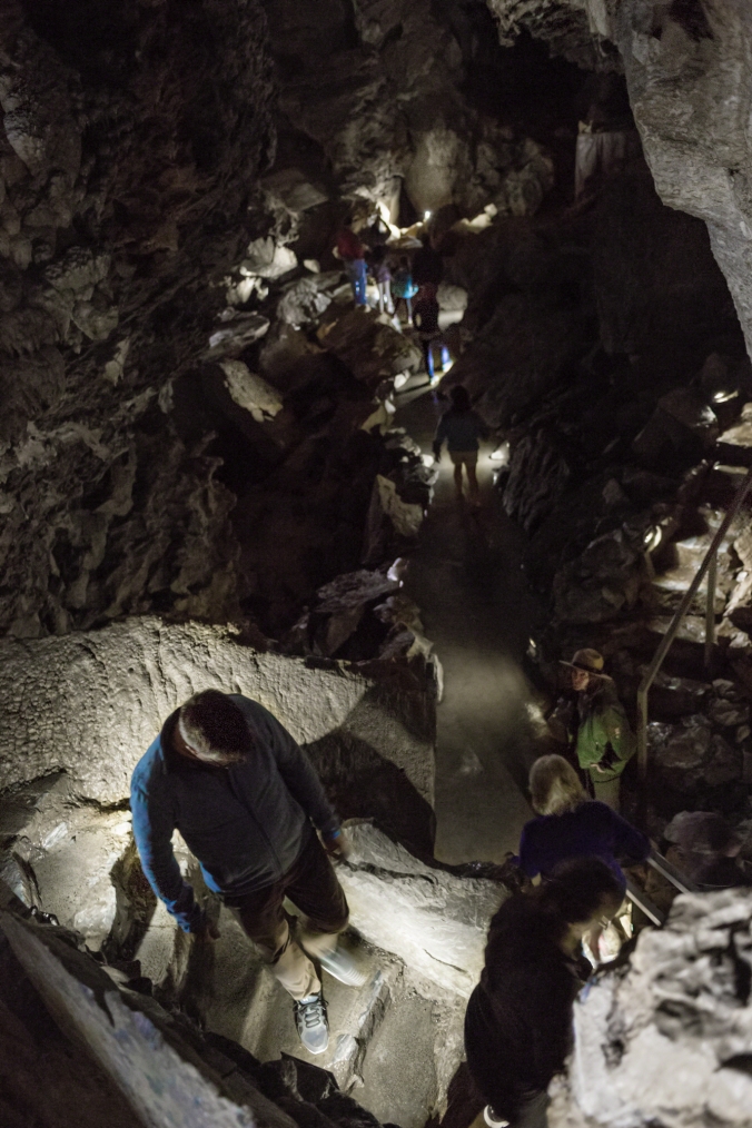
(A ranger guides visitors through the Oregon Caves on the Discovery Cave Tour.)
You can also hike above the caves to Big Tree, the largest known Douglas fir in Oregon, through groves of Port Orford cedar, another tree unique to southwest Oregon and northwest California; or if you’re feeling very energetic, climb Mt. Elijah, the granitic pluton that was forced up by the collision of North America and the old islands, increasing the geological pressure that crystalized the reefs into marble.
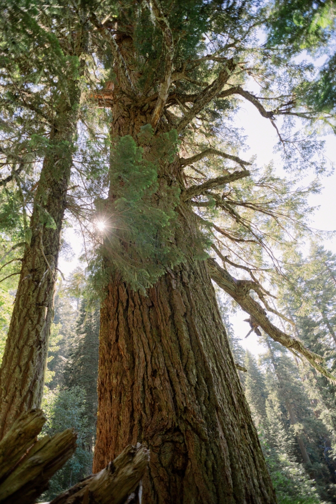
(Big Tree, the largest known Douglas fir in Oregon, estimated to be an amazing 1,200 years old)
You can climb the mountain from the caves, or drive to a closer trailhead in a high clearance vehicle. Both of these trails are covered by Sullivan in his Southern Oregon 100 Hikes/Travel Guide and maps are available from the monument. Mt. Elijah is in the Rogue River–Siskiyou National Forest, so dispersed camping is allowed, but be cognizant of the fire danger. The Cave Monument also hosts an historic lodge (with a café and restaurant) known as The Chateau — a beautiful example of Park Service architecture, furnished with restored Mason Monterey furniture.
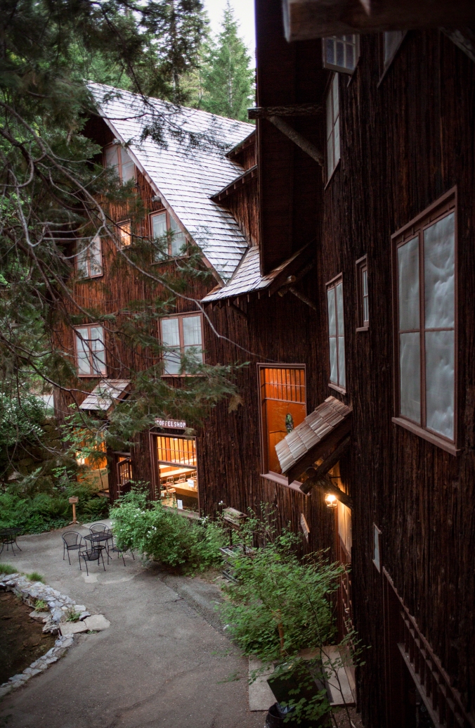
(The Chateau, the historic lodge at the Oregon Caves National Monument)
(Historic Mason Monterey furnishings at The Chateau)
The next day, you can move on to Ashland, one of Oregon’s most popular towns, renowned for its Shakespeare festival. Better-than-run-of-the-mill accommodations abound, from a mid-range, restored, modern vintage hotel in the hills, to a swanky historic 1920s luxury hotel downtown. The number of B&Bs and vacation rentals is almost overwhelming, as is the number of excellent restaurants.
Before you catch a show at the theatre in the evening, drive south of town to see a different kind of show, up on Mt. Ashland. As you wend your way along Mt. Ashland Ski Road (NF-20), Morris Bishop points out that you can see in the road cuts the lighter colored granite that intruded, about 150 million years ago, from the Earth’s molten mantle into the darker colored sedimentary shale of the ocean bed, creating an almost cross-hatched pattern.
(The newer, white granite that ballooned up from below the former ocean bed, creating Mt. Ashland, can be seen intruding through the cracks of the older gray shale alongside Mt. Ashland Ski Road.)
Stop at the first crossing of the Pacific Crest Trail over NF-20, just after the junction with NF- 2080, or Tolman Creek Road, to follow Sullivan’s recommended hike through Mt. Ashland Meadows. At the beginning of the trail, you’ll see the regionally unique Shasta red fir, a natural hybrid of the Noble fir and California red fir. Once you enter the meadows, you should be awash in native wildflowers. Plants and Animals of the Pacific Northwest by Eugene N. Kozloff has always been my trusty guide for identifying native plants on the trail in Oregon, but you can also download a free app to your phone called Oregon Wildflower Search, which works even without cell service.
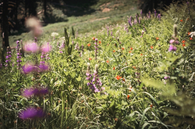
(Purple lupine, orange columbine, and white cow parsnip blooming in Mt. Ashland Meadows.)
As you hike, also look for granite with pink or white feldspar crystals, characteristic of Mt. Ashland’s pluton — most notable in large outcroppings in the forest. Before you reach gravel road 40S15, which, if you follow it north, will take you to nearby Mt. Ashland campground, you will get a good view of the much younger volcanic peak of Mt. Shasta, the second highest mountain in the Cascade Range.
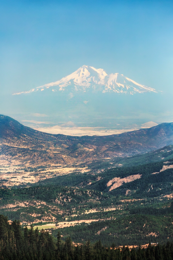
(Waka-nunee-Tuki-wiki, “to walk around and around, but never on top,” the center of the Shasta world.)
Many different indigenous people lived in the Oregon Klamaths before Europeans and their descendants arrived here – from the Chetco of the Brookings area to the Takelma around the Oregon Caves, to the Shasta people of the Ashland area, to name a few. Mt. Shasta is called Waka-nunee-Tuki-wiki in the Shasta language, which means, “to walk around and around, but never on top”, and the name-phrase would be repeated twice whenever a Shasta came in view of the mountain. Waka, for short, is also the name of the Shasta world-creator, who is said to have stopped on the mountain peak after making the world; the top of the mountain, above the tree line, was reserved for the supernatural. Shasta people went to the mountain to fast in search of medicine, or would walk once around the circumference of the mountain below the tree line to purify themselves, and if they were at the end of life, they would ascend above the tree line to die. Waka was to the Shasta people both the physical and spiritual center of the world.[1]
In Indian Legends of the Pacific Northwest, Ella E. Clark relates a tale from the Shasta about the animals of the world escaping a Biblical-type flood by waiting it out on the high peak of the mountain, the only thing that remained above water. This folktale has a chilling parallel in the oral history of the Shasta. It is claimed that in 1851, 175 Shasta men fled to the mountains to escape a genocide that was perpetrated against their people by the U.S. government and vigilantes. While this allegation has yet to be proved, other atrocities committed against the Shasta are well documented. Learn more about the First People of this area from Shasta Nation (Images of America) by Betty Lou Hall and Monica Jae Hall, members of the nation, and at the nation’s website.
Unfortunately, the Shastas’ language is no longer spoken fluently, as a result of the violence committed against them in the 19th century and the dispossession of their land and autonomy in the last century, though efforts are being made to restore their tongue and gain federal recognition for the tribe. For now, perhaps, the beauty of the Klamath mountains and the worth of exploring them may best be expressed by the region’s greatest English poet – John Muir.
“Climb the mountains and get their good tidings. Nature’s peace will flow into you as sunshine flows into trees. The winds will blow their own freshness into you, and the storms their energy, while cares will drop off like autumn leaves.”
*When planning hikes, make sure to check driving and hiking times and sundown time. [See the Google map I created for this trip: one-way standard drive times are noted in the directions on the sidebar. Click on the hiking icons to see estimated hiking times (not including breaks).] Always bring water, food, first aid supplies and a trail map, and prepare for weather conditions when hiking.
[1] Native American Interview by Dorothea J. Theodoratus and Nancy H. Evans.
Text copyrighted by Emily Wahl. Photos copyrighted by Eric Macey.
